Sunday, June 24, 2012

Journey's End: St. Marys

Jacksonville Beach was our last stop before St. Marys, Georgia. On gaining the St. John's River we decided to enter the Atlantic once again, as a south wind was predicted. But lo, once again the weatherman was wrong, so we mostly motored the last leg north. At about 1700 (5 p,m.) we docked at Lang's Marina, St. Marys, and that night we celebrated Jeff's 40th birthday to the accompaniment of a huge lightening and rain storm. One bolt even landed near us in the bay!

The following late morning we made our way up the North River to the St. Marys Boat Service to coincide with a noon high tide, and turned the boat over to a giant hoist, which carried Lily Rose to her new home on dry land.

Three days later, after preparing Lily Rose for her summer stay by removing her sails, cleaning her, and installing a humidifier to prevent mildew, we bid adieu. A few days later Tropical Storm Beryl stormed through with 65 mph winds, but no harm came to the boats in this yard. We chose well.

Historic St. Augustine

Before Jamestown there was St. Augustine. The Spanish built a fort out of seashells, but British
gunboats could not smash it; their shells just disappeared into its walls. Today the city is a visitors' delight. Its narrow cobblestone streets invite investigation, and its many charming cafes and boutiques summon the eye and taste buds. We look forward to a return visit and a chance to see more of it.

I only have one quibble. S/V Lily Rose ground to a halt less than a mile from its excellent City Marina when it slid up on a sand bar within the city's well-marked channel. Luckily, a good wind was from the north, which pushed the bow around and let me back off! We dined at its famous Columbia Restaurant and breakfasted at La Herencia on Avilas St., which serves fabulous Cuban coffee.

The long slog north

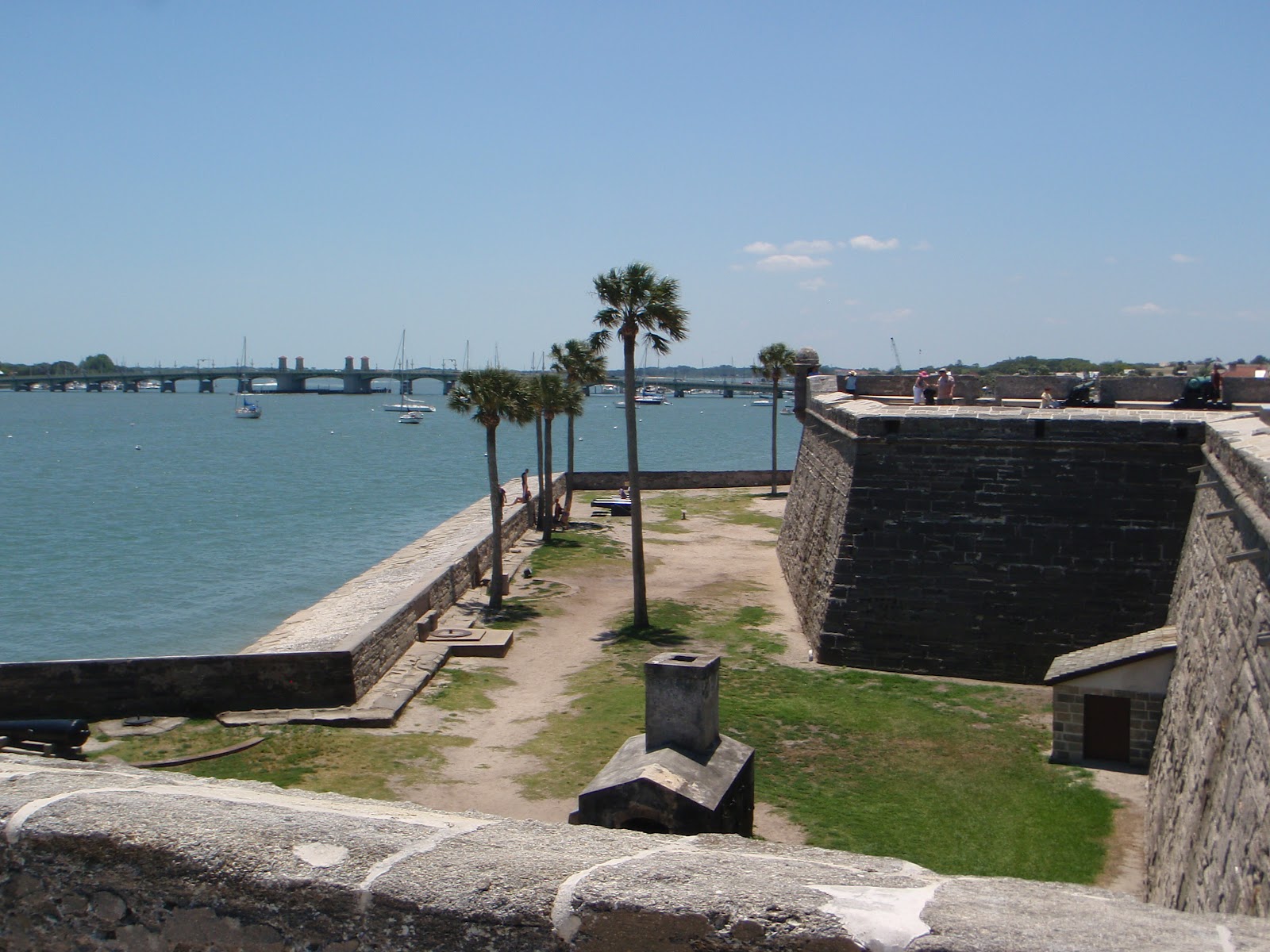
It took us 12 days of cruising, mostly on the motor, to reach St. Marys, Georgia. The wind was mostly from the north, allowing very few times when we could hoist a sail. And only once did we have the chance to slip out into the Atlantic. This was at the St. John's River north of St. Augustine, and then only for half a day until we reached the St. Marys Inlet.

It was a very pleasant sojourn, however, because of the variety of places we stopped at along the way. At Old Port Marina near North Palm Beach we arranged to have breakfast on board with a dear friend of Francie's -- Caroline and her four  children (husband working), who live nearby. One of the funkiest marinas was at Nettles Island, a man-made outpost on the oeean side of the waterway, where we celebrated Mother's Day with a special brunch at the marina's Landings Restaurant, a very excellent eatery. While there we walked to the Atlantic to dip our toes into the waves.


 After another stop at Fort Pierce where we anchored, we tied up the next afternoon at Florida Atlantic University's Harbor Branch (see submersible left), so Jeff and Mira could interview scientists there who were studying the effects of agricultural runoffs that were causing algea blooms detrimental to the coastal waters, fisheries, and coral reefs. The submersible was the first commercially-built sub that allowed divers to exit and re-enter while submerged. Researchers there have found that the toxicities of Gulf of Mexico oil spill dispersants are greater than that of oil alone in affecting corals, oysters, shrimp, conch, and their planktonic food sources.

Other stopping points northbound were the Vero Beach City Marina, where we moored, and the Telemar Bay Marina at Eau Gallie, where we docked and met a fun couple, Carl and Rosie on their S/V Windward Spirit, whom we hope to meet again next fall on their return from Nova Scotia. And before reaching St. Augustine, a highlight of our cruise, we also stopped at Titusville, New Smyrna Beach, and the Palm Coast Marina.


Into the Waterway

We departed Miami May 9 and pushed through a rainstorm in the Atlantic to Fort Lauderdale and the Intracoastal Waterway. This is where Bennie (left) said goodbye because he was convinced we could navigate north on the smoother waters safely. We were sorry to see him leave.

The Intracoastal Waterway is a maze of canals, rivers, bays, and large expanses of seeming lakes that exist between mainland Florida and a string of barrier islands facing the Atlantic Ocean. From Miami we entered the Atlantic via Governor's Cut, Miami's main commercial channel, to re-enter at Fort Lauderdale to avoid a myriad of bridges that are too low for most sailboats and thus have to open to let them pass. They must be hailed by VHF radio and either open by demand   or by a 30-minute schedule on the hour and half-hour or 15 minutes after the hour and 15 minutes before the hour. This requires some research in the cruising guides and references to the charts to learn their names and schedules. With practice we learned to avoid as many delays as possible by adjusting our speed from one bridge to the other. And as we
proceeded north we passed one palacial home
after another (see right), providing a glimpse into how that one-half of one percent of the nation's population live. We would also consult our guides to determine where we would end up every night. So after leaving the Las Olas Marina in Fort Lauderdale we proceeded to Del Ray after calling by phone the Del Ray Club Marina to reserve a slip. By the time we got there, however, a huge downpour enveloped our boat. But no problem, because Lily Rose came equipped with eisenglas panels we could zipper up to enclose the cockpit all around, which made for a cozy dinner that night!


Hello Jeff and Mira

At the Miamarina in central Miami we took on two more cruisers, Jeff Barbee and Mira Dutschke, his professional partner and sweetheart (see right). I met Jeff in Paonia, CO more than a year ago to discuss what he calls his Islands Project. Jeff is a photo-journalist and Mira is a lawyer and both work out of Capetown, South Africa. The Islands Project is to sail the Caribbean, interviewing scientists and others who are working on solving environmental problems. Jeff and Mira would create documentaries primarily for TV that combine the adventure of sailing the Caribbean with solid information about the environmental progress being made at islands that are more vulnerable to the stresses that are increasing worldwide, such as global warming, water and air pollution, diminishing fisheries, coral destruction, and endangered species. I agreed to include them in our cruise up the eastern coast of Florida, where we would stop at several locations where environmental work was taking place, such as the Harbor Branch of Florida Atlantic University at Fort Pierce. More on this later.

Saturday, June 23, 2012

On to Miami

We left Key West May 5 and mostly motored to Book Key and Marathon, mooring at the City Marina in a well-protected area (right). We met a couple from Annapolis on a catamaran who liked Marathon so much they have stayed for five years. A mooring only costs $325 a month. You can walk from the marina to everything you need, including a West Marine store. And buses can take you to Key West and Miami. Francie and I are considering Marathon as a place to keep Lily Rose for awhile.

                       
The next day we hoisted our genoa jib (left) and motor-sailed up Hawk's Channel to Rodriguez Key, where we anchored in 7 and a half feet of water! That night we enjoyed a super moon.

Then on to Biscayne Bay and Miami May 7, passing several homes on stilts, known as Stiltsville (right). Later, back in Colorado, Francie and I met the couple who built this house. Now Miami does not allow more. It was exciting to see the Miami skyline risng.


Saturday, June 16, 2012

Key West

One can dance a lot in Key West. In fact, there is a large statue of a couple dancng, so Francie and I decided to join in. (See photo to right). That's the spirit of Key West. We also took the Conch Train tour of the town, visiting Ernest Hemingway's House (see photo to left). My colleague Paul Hendrickson has written a book called "Hemingway's Boat" that mentions this house, of course. Our favorite cafes were Harpoon Harry's, where we drank gallons of delicious Cuban coffee, and an oyster bar near the marina. (See oyster eaters Larry, Bennie, and Bob below right).  And this is where we said goodbye to Sophy and Grady, who had to get back to work in Salt Lake City. (See them below). They rented a car and drove to Miami. We didn't get there until three  days later! We also caught the awesome sunsets at this tip of the American continent.


Thursday, June 14, 2012

A Long Night

The sunset was the best part of this leg of the trip.
Francie cooked an especially fine dinner, but as we put away the dishes the wind started picking up, and picking up. We had the first watch, from 2000 to 2300. By then we were pounding into six-foot seas and up to 40-knot winds. I went below to sleep, and almost immediately became violently sea sick. There went the dinner and my pride! I then collapsed on the starboard couch, not to rise again until morning. 

What happened that night comes from the others. All but me stayed in the cockpit. Grady wanted to sail and alter course farther to the west. The boat weathered the 40 knots but life in the cockpit was
reportedly very uncomfortable. All but Francie and Bob got sick. Finally Bennie took charge, ordered the sails down, set the course back to due south, and motored on. By dawn the weather had calmed down and we arrived at Key West about 1300 (1 p.m.) and docked at the Conch Harbor Marina. We all wandered around town but had no energy for partying that night!


On to Key West

We pulled anchor at 0925 and headed down Sarasota Bay and out into the Gulf through a narrow inlet. Then headed south into big winds gusting from 20 to 40 knots! The crew was slow to get the sails down, causing a rip in the big 130% genoa along the cover. We also noted that the boat under power was not going as fast as it should. Five knots turned into three knots and even one knot as the wind increased! We almost lost steerage way driving east into the wind into Charlotte Harbor through a very narrow inlet. But with persistence we slowly made our way to Useppa, where we anchored in the dark at 2130. Whew!

The next morning we discovered why we had less power. Bob Mothershead dove to discover our propeller and rudder encrusted with barnacles. I had had the boat hauled and hull repainted in January, but forgot to get the propeller and rudder scraped before we left St. Petersburg. Bad me! Good Bob! Bennie used his local contacts to find a sailmaker near Estero, our next stop. So we chugged down to the Salty Sam Marina arriving at 1530 to hand our genoa over to Kurt Martin of Sail Service & Repair, who fixed the tear that night.

The next morning we retrieved our sail and departed nearby Fort Myers into the Gulf again at 1400 or 2 p.m. The plan was to sail all night due south, leaving the coast far offshore, to arrive at Key West by noon.

Wednesday, June 13, 2012

The First Day


We departed the St. Petersburg Municipal Marina at 0920 (or 9:20 a.m.), entering Tampa Bay and heading west towards the immense Skyway Bridge. The wind was light so we motored along the shipping channel. Once past the bridge (see photo) we turned south towards Sarasota, a major city and our destination that day. I was glad Bennie Ficarrotta was with us because he knew these waters and where not to venture because of the shoals. He set a way point to enter the narrow channel leading to Sarasota Bay. This is part of the Intracoastal Waterway that winds between the Florida mainland and the the barrier islands that front on the Gulf of Mexico.

Way points are established on a navigational device called a chart plotter, which on Lily Rose is located above and in front of the steering wheel in the cockpit. Its display, which looks like a computer screen, shows the area the boat is navigating and the location of the boat. The display can be manipulated to enlarge the area or decrease the area shown, to provide more detail. Navigational markers, usually buoys, are shown to help the helmsman steer a safe course. But much more information is provided,  including weather, depending on what services one sets up. The buoys are colored red or green to mark the channel's safe width. Sail boats like Lily Rose also are equipped with depth finders that tell you how much water is below your keel in feet, and the charts one loads into the chart plotter also provide water depths. When you set a way point on your chart plotter, the plotter also displays a course line from your boat to the way point, which gives the helmsman the direction to steer. But one must be careful to note the courses depth of water, because way point courses merely mark the straitest way to go. This is no problem when you are in deep water at sea. But in shallow bays and inlets, way points are less useful. Thus in this case, Bennie set a way point when we were in the deeper water of Tampa Bay to get to where the narrow channel to Sarasota begins. Then we steered entirely by noting the red and green buoys to keep in the middle of the channel.

At 1630 (or 4:30 p.m.) we anchored just off Sarasota and Marina Jacks, a fancy marina Francie and I had once considered as a temporary home for Lily Rose. But we didn't feel the marina fitted our style and chose the St. Petersburg marina instead. Our dock there was filled mostly with sail boats (instead of motor yachts) and many had live-aboards. Francie fixed a delicious dinner and so ended our first day.

Sunday, June 10, 2012

Adios St. Petersburg

We left the St. Petersburg Municipal Marina on April 29, 2012, bound for St. Marys, Georgia. On board were myself, Francie, Sophy and Grady Kohler, Bob Mothershead, and Bennie Ficarrotta. Our route was to round the Florida Keys and proceed up Florida's east coast. I will describe this voyage later, but we arrived St. Marys May 22 and put the boat "on the hard" at the St. Marys Boat Services yard on the adjacent North River the following day. Little did we know that Tropical Storm Beryl would soon hit the area, bringing 65 miles an hour winds. After Francie and I arrived back at her home in Nokomis, Florida, we watched the weather reports with horror. But not to worry. Phone calls to the yard confirmed that the storm caused no damage. My insurance broker's advice to take the boat to St. Marys because "it was the safest place on the Atlantic seaboard" re hurricanes proved correct.